Story Info
Story Info
Beate Sass
Albuquerque, NYM
2023
Type of Wounded Place
Story & Experience
Albuquerque, NYM
Act of Beauty
Say more about your actions and activity
Photos:
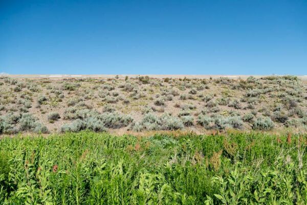
Featured photo: View of the backside of the spillway. The foreground is the lowest part of the basin so it tends to be wetter than any other area, thus the lush sampling of curly dock, an edible invasive. Chamisa and cacti are sprinkled along the hillside.
Below:
1: Approaching the John B. Robert Dam at sunrise
2. Cholla cactus
3. As I walked along the top of the Dam I noticed Maurice, standing on the rim, looking towards the West, holding a heart-shaped rock. He was brilliantly illuminated by the sun as it was setting. He told me that he was passionate about handmade art and that he restores old rugs. He derives tremendous pleasure from repairing rugs that were handmade by his elders and restoring them to their original form. His craft has been passed down to him through many generations. Like the earth on which this Dam stands, Maurice is restoring beauty to a damaged place.


RECENT STORIES
For the Gulf Coast
Our beaches are being bombarded almost daily since the end of the first week of the sinking of the Deep Water Horizon with gatherings of people or all stripes: protests, prayer groups, volunteers, rallies for [...]
Remembrance Day for Lost Species in Helsinki 2023
On November 30th, there was first a session organized by the Finnish social and health sector project about eco-anxiety and eco-emotions (www.ymparistoahdistus.fi). This “morning coffee roundtable”, a hybrid event, focused this time on ecological grief [...]
Ashdown Forest
Ashdown Forest is an area of natural beauty in West Sussex, England. It is also one of the very few remaining areas of extensive lowland heath left in Europe. This rare and threatened landscape is [...]